VDOT and its allies have claimed that a new milestone has been reached in the Route 29 Corridor Development Study. This study is an extension of the I-66 Corridor Study, and is an apparent attempt to provide additional developer roads through Western Prince William County, as well as the diversion of regional commuter traffic into the part of the county north of the Battlefield.
The options being hailed for "further study" are extremely damaging, both to the historic and cultural areas of the county as well as posing a significant public safety hazard for the residents of Western Prince WIlliam County. Further, there is a significant potential to impact commerce in the region by diverting the customer base from many local Manassas merchants into a more readily accessible Warrenton economy.
CARD urges all citizens to attend if possible the public meeting sponsored by VDOT:
January 8 1998
6:00 PM to 9:00 PM
Holiday Inn
10800 Vandor Lane
Manassas, VA
(Located off I-66 and Route 234)
Why, the usual people. Those with a profit motive in developing the region. The folks that want to sell off their Disney land investment. The professional developers, and the local politicians they sponsor.
VDOT has a site on the study. VDOT lists the participants of the Technical Advisory Committee as:
- Arlington County
- City of Fairfax
- Fairfax County Office of Transportation
- Fauquier County
- Loudoun County Department of Planning
- Prince William County (more on this later!)
- Metropolitan Washington Airports Authority
- Metropolitan Washington Council of Governments
- National Park Service
- NCR Transportation Planning Board
- Northern Virginia Transportation Commission
- Potomac &Rappahannock Transportation Commission
- Virginia Railway Express
- Washington Metropolitan Area Transit Authority
A more interesting question is who is not on the study. Why, the people that live here, of course! Those that farm here, that are born, grow up, raise their families and pay taxes here, die and are buried here...what interest could they possibly have in such an important study! And there is clear evidence that VDOTs "Most Promising" alternatives put them at severe risk.
Is Prince William Represented?
Well, that´s a good question. The Prince William County Board of Supervisors approved an additional option (the Short Northern Bypass Option) to the study in their regular meeting on November 18th 1997. This action was not publicized in advance, nor was it listed on the meeting agenda. Public input was excluded by definition. (Not even the usual lip service!) CARD described this at the time as another example of a covert local government action and points out that most of these actions are performed in secret because they tend not to fare too well under the light of day. (Perhaps we should call these Vampire Votes!)
There were those that hailed this act, an example was Falls Church resident Bob Chase. Although we appreciate Bob´s comments and labels ("...might have angered the small, vocal clique who oppose all new roads") as much as the next man--it is pretty clear that the Prince William County vote in all this went to Falls Church!
What are They Trying to Do?
Note--Despite VDOT´s refusal to post any detailed information relative to this study on the web (another Vampire act folks) CARD has posted some maps describing these proposals on the bottom of this page.
Although the Spin Doctors have wrapped this in a "historical and environmental" candy wrapper, this is yet another attempt to open the western part of the county to sprawling development. The reported purpose of this study is to re-route Routes 29 and 234 away from the park. However, the options selected dirvert the regional traffic pattern (which in all cases serves areas South and West of the park) into the sparsely developed region North of the Park. This provides ready highways to serve development North and West of the Park, as well as displacing current low density residents and farmers by both condemning their land for the highways as well as isolating them from schools, shopping areas, hospitals, and fire and rescue services.
The regional traffic problems associated with Route 29 are due to regions South and West of the park; a true solution involves those areas--not the area North of the Park!
Open your eyes and its easy to see. Anyone that drives a car around here can tell you where the Rt 29 Commuter Traffic problems are!
1. Manassas/Southern Prince William: Depending on the state of Route 66 (a construction or accident tie-up makes this much worse) a differing number of people use Rt 29 as an I-66 bypass. Most of this traffic turns left (south) on Rt 234. A bypass North of the Park does not help these people-it just makes things worse! The solution is to expand Route 28 and I-66 so that they may better serve the existing demand.
2. DC Side of Warrenton: Many use Rt. 29 to go to GAINsville and on to Fauquier County. Interstate 66 would be a better option if it weren't so congested with Manassas bound traffic. The solution here is again to fix Interstate 66 so that it could serve the existing demand.
3. Pageland Lane: There is a large contingent that goes out Rt 50 to Gum Springs Rd, and after a brief transit of Rt 234 they head down Pageland Lane to westbound Rt 29. This is a pretty clear attempt to avoid the overcowding on I-66 and its overflow onto Rt. 29. The solution here is again to fix Interstate 66 so that it could serve the existing demand.
4. Nissan Pavilion Traffic: Although its hard to believe that anyone would allow a developer´s facility to be built without requiring the beneficiary to fund improvements needed to support the facility...Nissan Pavilion traffic has been diverted north on Rt 234 and west on Rt 29 to relieve the congestion on Ball´s Ford Road. Closing those routes through the park is clearly in the best interest of anyone living north of Interstate 66 with regard to Pavilion Traffic, but it does not solve the problem!
How do These Options Threaten Western Prince WIlliam?
CARD urges citizens to study the option maps below. The Falls Church solution is fatally flawed in two regards:
1. It does not address the regional transportation issues (see above) it just diverts a problem South of the Park to the North of the Park.
2. The solutions offered cut off the residents of Western Prince William County from Schools, Hospitals, Fire and Rescue Protection, and commerce. Look at the maps. In all options but the do nothing option--there is no good way for Western Prince William county to access Manassas. Now we certainly do appreciate Bob´s comments about what is best for us (and after all most of us that live out here aren´t too bright or we probably wouldn´t need good old Bob to tell us what´s Best) but we are having a little difficulty understanding how we are going to be better off when we need access to Manassas for:
Schools: There are no High Schools in Western PWC. There are no Middle Schools in Western PWC. There is one elementary school in PWC. Our children transit Rt 234 daily to Marsteller and Stonewall. Do we put these kids out on I-66? Should we route them through the industrial congestion on Ball´ Ford. No way. Look at the map folks--see what your Falls Church and Fairfax County betters and your "Vampire Voting elected officals" are proposing for your children.
Hospitals: Same story, same players. How does Western Prince William County access Prince William Hospital Center?
Fire and Rescue: Western Prince William has one Fire and Rescue Company at Evergreen. How will this company share equipment and personnel with other companies during periods of crisis? By getting stuck in yet another I-66 traffic jam? No way.
Commerce: Hey all you merchants in Manassas. Does anyone from the western end of the county ever spend money in your stores? Buy pick-ups and service them at your dealerships? Look at the map. Its going to be just as easy for us to drive to Warrenton.
What Can We Do?
CARD urges all citizens to take a look at the maps, think about the proposals. Attend the meeting on January 8th at the Holiday Inn. Ask your officials:
1. What good are these proposals when not one of them addresses the real problems--the inability of I-66 to meet current traffic demand.
2. Tell them you won´t stand for the endangerment of the Western Prince William school children or populace.
3. Tell them to go off and find a solution to their problems, instead of proposing a Developer´s Highway as a solution to a regional problem.
The Proposal
Note--CARD has done as well as it could with its limited resources to represent the VDOT Rt 29 Corridor Study proposals. We have tried to be as accurate as possible. If we have made any errors we are sorry, but then again its not our job and we certainly would have rather seen VDOT use some of our tax dollars to tell us what they are up to instead of using them for Environmental Impact Studies for Developer Roads. Its not like we didn´t ask them to keep people informed.
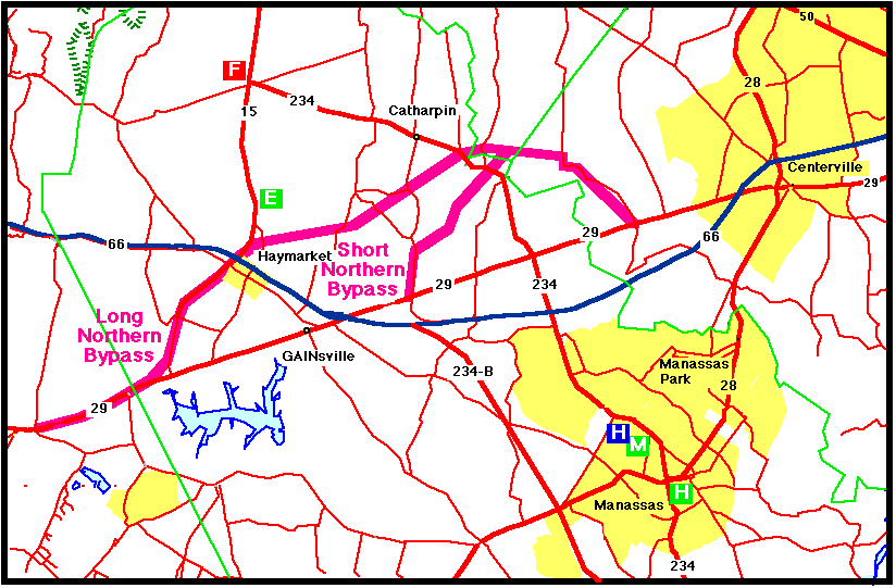
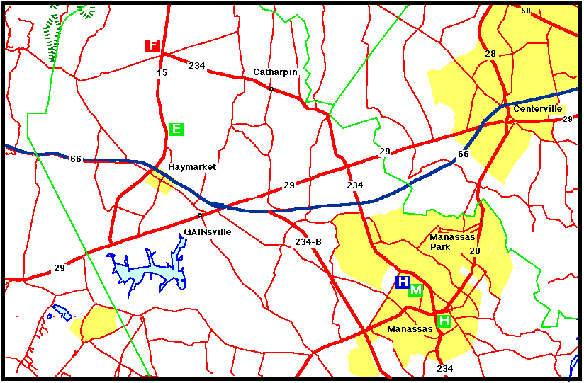
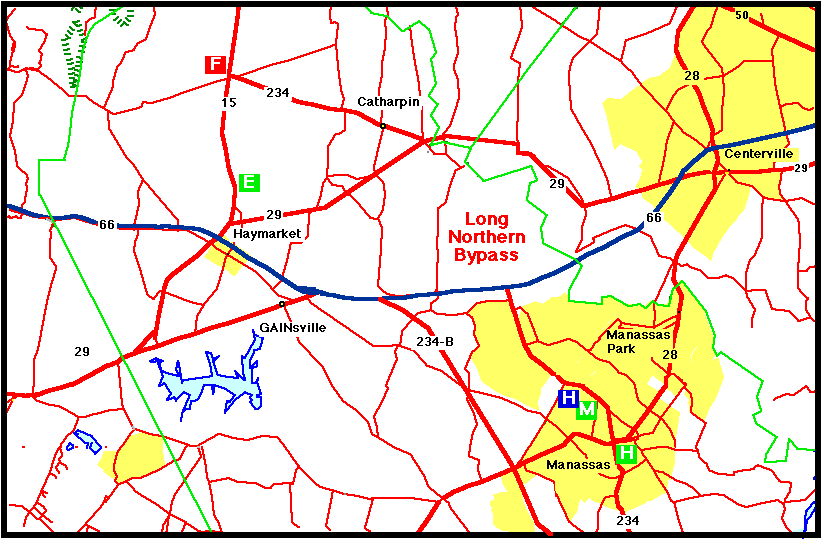
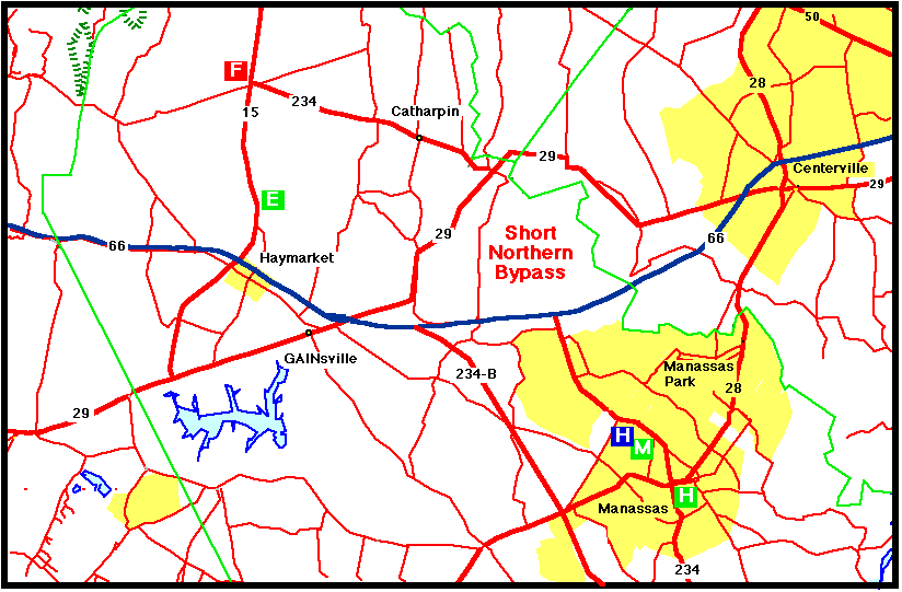
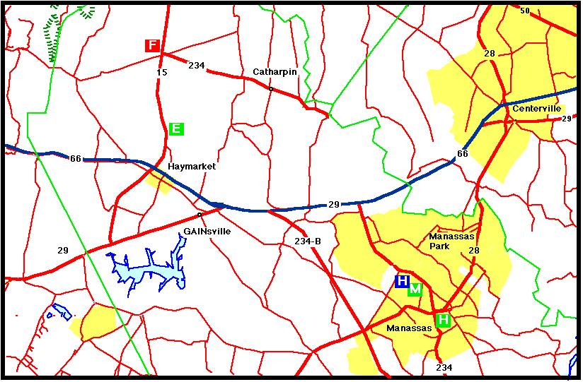
1. Overall Map:
2. Option 1: No Build - No significant changes to Route 29 through the study area.
3. Option 2: Long North Bypass - This alignment bypasses Manassas Park to the north and returns to the existing Route 29 alignment near Vint Hill Road.
4. Option 3: Short North Bypass - This alignment bypasses Manassas Park to the north and returns via route proposed but not approved to run the 234 Bypass north of Interstate 66--the "Powerline Corridor." This alignment was the one approved by the Prince William County Board of Supervisors without public notice or comment.
5. Option 4: Let´s Call I-66 Route 29 - This option solves traffic problems by giving a road a new name; lets call I-66 both I-66 and Rt. 29.
Hope to see you there on 8 January.