Littoral Regions
Historical Geography of Medieval America:
- Climate
- Terrain
- Population
- Littoral Regions
- Navigable Rivers
- Borders
- Cities
A littoral zone is a special kind of cultural region found on complicated coastlines.
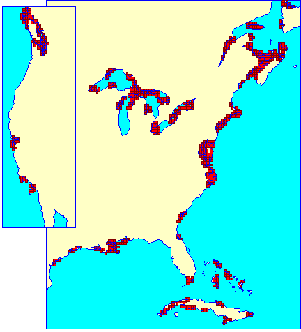
Littoral zones are not merely coastal; they are regions in which your neighbor is more likely to be across the bay rather than down the road. They are the tips of peninsula, offshore islands, embayments and estuaries. A long smooth coast does not stir seafaring ambitions because there's no place to go except out into the open sea, but a crinkly, convoluted collection of bays and islands gives the local inhabitants plenty of sailing practice with short easy hops. Similarly, a smooth coast is not going to attract the attention of seafarers because any camp they set up will be vulnerable to attack from the land, but a peninsula or island makes a better stronghold.
To pinpoint the littoral zones of North America, I used a technique explained in detail in Colin McEvedy's Penguin Atlas of Ancient History. Basically, you plant a grid over a map of the coast. Then, in blue, you color every square which contain a piece of the coastline. Next, in red, you color every square in which a majority of its neighbors are coastal. It doesn't matter whether this square is coastal itself, only that most of its neighbors are. McEvedy applies this technique to the Mediterranean and shows that the areas which became colonies of the great ancient mariners -- the Greeks and the Carthaginians -- had a geometric unity that other areas lacked. This technique also highlights the principle sea powers of the Middle Ages -- the Venetians, Byzantines and the Genoese -- although McEvedy does not mention this.
If my map of littoral America looks vaguely familiar, that's because land and sea have already come into conflict twice in American history. The first time was when the Europeans first colonized the shores of North America, and sure enough, their primary effort fell in the larger zones shown on the map: the Chesapeake Bay, Long Island Sound, Massachusetts Bay and Nova Scotia. The second time was during the Civil War, when the US Navy imposed a blokade on the Confederacy, and the earliest successes were often in areas highlighted on the map: the Chesapeake, Albemarle Sound, the Sea Islands and the Missisppi Delta.
In Medieval America, there would be a strong tendency for the littoral regions of a particular coast to be joined into a maritime empire of some sort, and to develop a separate culture from their inland neighbors.
| See Also... |
| United States of America |
| Louisiana |
Last Updated 1996
Copyright © 2003 Matthew White